
Trace a Town of Wallkill Street
A Town of Wallkill street directory is an address trail. Orange County GIS can locate a street or parcel. The Town tax search and Beacon property system can supply owner and tax-map clues. A current deed reference and legal description then lead to the County Clerk's land records. Each record has its own purpose. A mapped parcel shows location and boundaries. A tax record follows the account. A deed records a land transaction. Older directories and census material can add a household clue, but they do not replace the parcel evidence.
Check the municipality before relying on a city label. Town of Wallkill nearly surrounds independent Middletown, and 10940 or 10941 mail may appear for property that is in the Town. Retain the exact address, tax-map or SBL reference, parcel identifier, property location, and owner field as the record displays them. That set is more reliable than a surname or a street name alone.
- Enter the exact address in Orange County GIS Locate or search the parcel layer by Street Address.
- Limit the search to Town of Wallkill when the municipality control is available and record the parcel ID or SBL.
- Compare the Town tax or Beacon property result, keeping property location separate from the owner mailing field.
- Use the deed book and page or legal description to identify the recorded instrument in County Clerk records.
- For a past household, compare a confirmed directory or census year with the same parcel and date range.
- Ask the Building Inspector or submit a focused FOIL request for a permit or inspection trail when that record type matters.
Wallkill Street Directory Tax Fields
The Town of Wallkill BAS tax search gives several routes into a single property account. It has a Collection selector plus Bill #, Tax Map #, Property Address, and Owner Name inputs. The documented collections reach Town and County tax years from 2008 through 2026. This is a practical street directory entry point because a partial street or a known owner can be tested against a tax-map reference. The research did not capture a public result-grid field list, so a matched screen should not be described as if it supplies fields that were not verified.
| Field or mode | Street-directory use |
|---|---|
| Collection | Select the appropriate tax collection before searching. |
| Bill # | Open a known tax-account record. |
| Tax Map # | Carry the parcel clue to GIS and land records. |
| Property Address | Search by a physical street location. |
| Owner Name | Check a plausible recorded owner connection. |
Beacon is the county's free current property route. It documents Owner Name, Address, Tax Map Number, and Municipality modes, which makes it a companion rather than a duplicate of the Town tax form.
Orange GIS Along Wallkill Streets
The Orange County GIS parcel-search help documents Owner Name, Street Address, Parcel ID, and municipality scope. Partial text is supported. The help example says a Street Address search for “View” can return streets such as Riverview and Viewcrest. Scope can be all municipalities, selected municipalities, or the visible map area. That makes GIS the useful first map layer for a street directory search when the spelling or suffix may be uncertain.
| GIS control | Verified behavior | Meaning for a street search |
|---|---|---|
| Owner Name | Optional text with partial matching | Tests a possible recorded property connection. |
| Street Address | Optional text with partial matching | Finds candidate addresses sharing a street fragment. |
| Parcel ID | Optional text input | Reconnects a tax or deed clue to the map. |
| Municipality scope | All, selected, or visible area | Keeps a Wallkill search from drifting across the county. |
| Search and Reset | Run or clear criteria | Refine a group of possible street hits. |
The GIS search help shows the county's documented parcel-search choices.
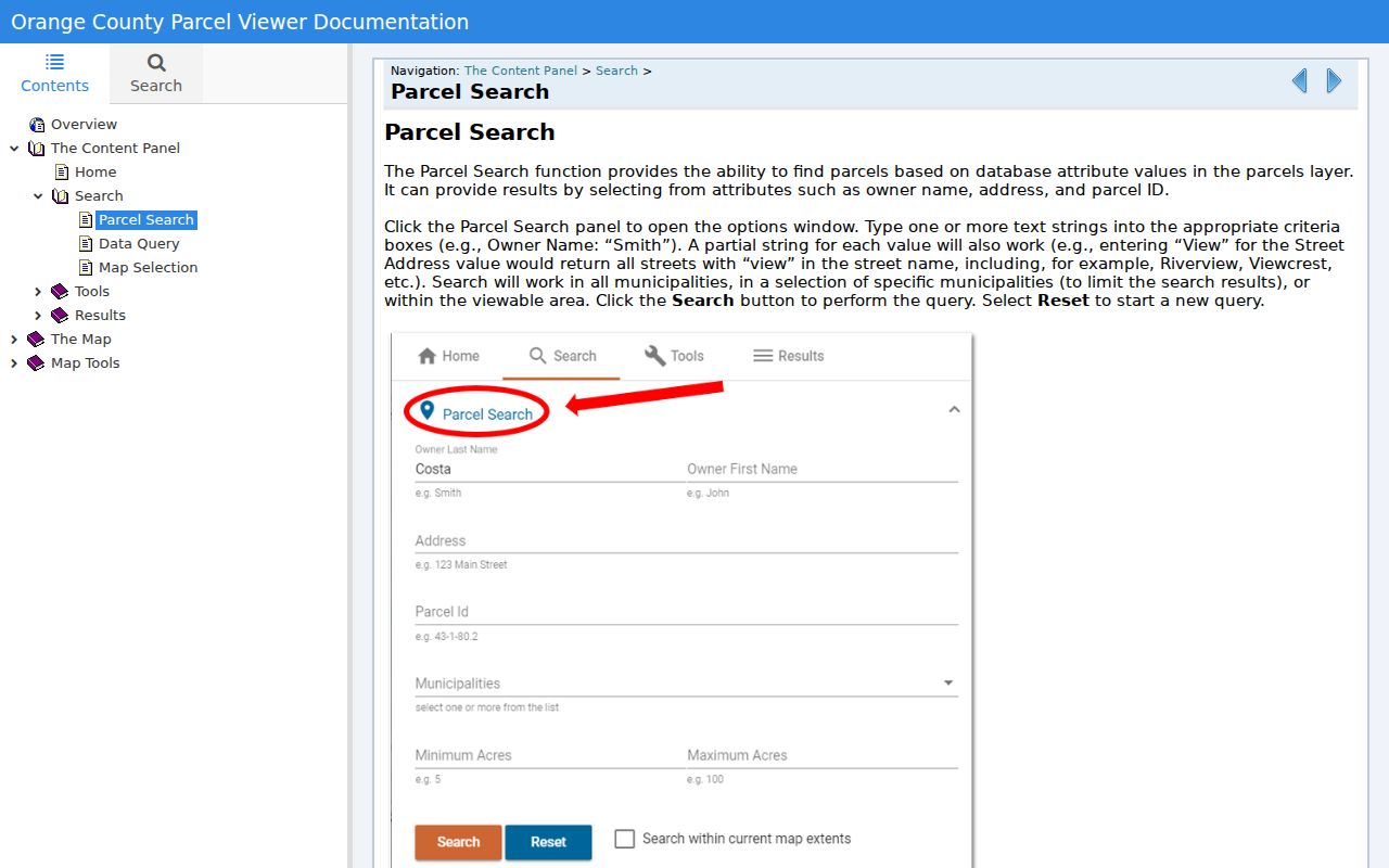
After selecting a parcel, use its map and property links as confirmation steps rather than assuming a partial street match is unique.
Wallkill Parcel and Road Evidence
The ParcelViewer service adds road labels, address points, parcel boundaries, municipal boundaries, parcel IDs, and school, fire, police, EMS, legislative, and election districts. Its listed parcel fields include PrintKey, SWIS, PIN, SBL, owner, property class, school district, Street Address, City State Zip, and street components. The Roads layer has alternate-address and left-right address ranges. These layers help place a road segment and a parcel in their public map context.
The county calls GIS data informational rather than a legal survey or engineering document. Use the map to correlate records, then confirm a legal description or recorded map at the County Clerk when a document needs exact land identification. The street directory should not turn a mapped owner field into a claim about every person associated with an address.
- Parcel
- A mapped tract used in property and tax systems.
- Situs address
- The physical property location, which may differ from a mailing address.
- Plat
- A recorded map that can show lots, blocks, roads, or subdivision relationships.
- SBL
- A tax-map land reference used to keep a record trail tied to the right parcel.
Town of Wallkill Street Records
Address-keyed records in Town of Wallkill work best as a chain. Property and tax tools identify a parcel. GIS displays its location and nearby context. Deeds and maps provide the recorded transaction and legal-description layer. Building files can date permitted work. Historic sources add a past household or street clue. They do not all answer the same question, and none provides a complete resident list for a road.
| Address record | Keeper | What it shows | Access channels |
|---|---|---|---|
| Beacon property information | Orange County Real Property | Owner, parcel, values, tax map, photo, and comparables described by county | Free portal; Real Property desk |
| Town tax record | Wallkill Receiver of Taxes | Bill, tax-map, owner, property-address keys, and collection context | BAS search, counter, mail |
| GIS parcel viewer | Orange County GIS | Parcel, address point, districts, and mapped selection | Public map and GIS office |
| Deed or mortgage | Orange County Clerk | Recorded parties, transaction, legal description, and reference trail | SearchIQS, Record Room, historic indexes |
| Permit or code file | Town Building Inspector | Application, permit, inspection, certificate, or notice history | Phone, counter, or focused FOIL request |
| Historic directory or census | Thrall, OCGS, County Clerk | Past household and street clues, not ownership proof | Library, archive, microfilm, Record Room |
Note: The parcel number and legal description are the safer link between a Wallkill street address and a recorded land instrument.
Wallkill Deed Chains by Address
Orange County's land-record route is the step after an address becomes a specific parcel. The County Clerk's Online Records page connects to SearchIQS. The county publishes $15 one-day access, $5 per downloaded or printed document, $150 for 90-day in-state access, and $600 for 90-day out-of-state access. The web page does not state one simple online coverage-start year, so do not assume a record is absent because a subscription search does not show it.
The Record Room at 255 Main Street in Goshen is the practical alternative. It provides free public computers for online records and materials such as deeds, mortgages, assignments, satisfactions, maps, old atlas maps, liens, judgments, and court actions. Plain copies cost 65 cents a page with a $1.30 minimum. Certified copies cost $1.25 a page with a $5 minimum. The counter also helps when an old book, map, or image is outside web access.
A grantor conveys an interest. A grantee receives it. Start with the current owner, tax-map reference, and deed book/page. Locate that acquisition deed, follow the seller as the next earlier lead, and carry the legal description through every transfer. A street label alone is not enough for a reliable title chain.
Wallkill E-911 Street Numbers
Town Code Chapter 171, adopted May 23, 2002, connects property numbering with countywide enhanced E-911. It requires assigned numbers to be displayed by the roadway and at the building. The Building Inspector and police enforce the display rule. That is a real local address-control fact, but it is not a historical renumbering table. No official townwide old-to-new number or street-name conversion source was located in the research.
Subdivision-street rules add another useful caution. Proposed names move through planning approval, should not be confusingly similar in sound or spelling to existing names, normally use names rather than numbers or letters, and require USPS clarification. A street that changes direction by more than 90 degrees normally needs a name change. Search the full name, a stripped direction or suffix, and the older spelling, then confirm the candidate with a parcel or legal description.
Wallkill Building Files by Address
Town Code says the Building Inspector receives applications and issues permits, certificates, notices, orders, and inspections. It also requires permanent records of applications, permits or certificates, fees, inspection reports, and notices or orders. The code identifies those records as public for proper-request inspection during business hours. They can show when work was proposed, approved, inspected, or certified. They do not establish that a named person occupied the property.
No official public permit-search interface was found. Call the Building Inspector at 845-692-7808, ask at Town Hall, or use the Town FOIL form for a narrow existing record series. A request should name the address, record type, department, and date range. Certificates of occupancy have a tighter access rule in the Town code, so they should not be treated as unrestricted copies.
Earlier Wallkill Street Clues
Historic city directories near Town of Wallkill are Middletown-centered, not a complete rural Town census. The digitized 1857-1858 Middletown Directory can show alphabetic surnames, initials, occupation or business, and a printed street. Thrall microfilm lists city directories from 1871 through 1984, with documented gaps. An old entry is useful for a household or street lead, but it needs a municipal-boundary and parcel check before it becomes a Wallkill address claim.
Orange County Genealogical Society and the County Clerk give the older fallback chain. OCGS holds grantor and grantee microfilm for 1703-1891. County historical material points to FamilySearch deed books and index books for 1703-1900. Use a confirmed directory year with the deed and census timeline. The historical collection details are maintained on the Town of Wallkill city directory page.
Wallkill Street Voter Boundaries
New York voter information has a narrow purpose. The state registration lookup is an identity-based self-service route, not an anonymous street directory. A broader voter-data request must state an elections purpose under Election Law section 3-103(5). Election Law section 5-602 describes time-bound public examination of county voter lists by election district before a general election. That rule does not create a continuous street roster.
Use a known address to identify a parcel and election district, then ask the Board of Elections about the appropriate current procedure. Confidential registration under section 5-508 remains unavailable for ordinary public inspection. The official Town election-district map is geographic context only. It cannot show every household member along a street.
Limits on Wallkill Street Searches
Property, tax, and deed records identify a public property interest, not every adult, child, guest, or other person connected to the location. Public utilities and delivery lists are not a valid source for this research. Motor-vehicle addresses have separate restrictions under the Driver's Privacy Protection Act. Address Confidentiality Program participation and confidential voter registration can also keep address information from ordinary public examination.
For a block around one parcel, use the GIS selection and buffer process described in the Town of Wallkill neighbors lookup route instead of trying to make a full-street record trail do a different job.