
Town of Wallkill Neighbor Sources
For a Town of Wallkill block, start with the public map and keep the question narrow. Orange County GIS can place an address on a parcel and show the parcels around it. The property and tax systems add the public owner and parcel context for one selected parcel. The County Clerk holds recorded land instruments when a property history matters. Election records are a separate, time-bound source. None of these sources turns proximity into proof that someone lives in a particular home.
| Source | What It Shows About a Block | Access |
|---|---|---|
| Orange County GIS parcel and buffer tool | Parcels surrounding a selected parcel, road and address points, and district boundaries | Public map; a buffer is spatial, not a household roster. |
| Beacon, assessment, or Town tax system | Public parcel, owner, and tax context for an individual nearby parcel | Use Beacon or the Town tax search; an owner is not every resident. |
| Orange County Clerk land records | Recorded transactions and legal-description history for a parcel | Online Records, Record Room, and historical index channels; verify parcel by parcel. |
| Election district and Election Law §5-602 lists | Election-district geography and a limited public-list rule at a particular time | Confidential registration and purpose restrictions still apply. |
| Community and historical collections | Published contacts or older community material where a holder actually makes it available | No authoritative townwide HOA or member directory was verified. |
The distinction matters. A parcel record can connect land to a recorded owner or a tax mailing address. It does not identify every occupant, child, guest, or adult in a home. Keep a map result tied to its own parcel and source rather than treating a nearby address as a personal profile.
Map Town of Wallkill Neighbor Parcels
The Orange County GIS map viewer supplies the documented route from a known address to its immediate surroundings. Parcel Search accepts owner name, street address, or parcel ID. The Locate tool can also take an address, city, state, and ZIP. Partial entries can return more than one result, so confirm the town municipality and parcel before treating a map point as the right property.
County GIS results help shows the buffer method used for Town of Wallkill neighbors. The selected feature receives a matching Data Results row, and the Zoom control centers it.
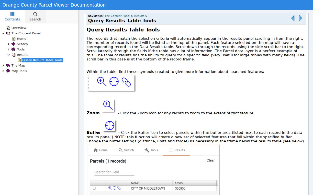
The Buffer control creates a new set of parcels within the chosen distance, units, and target. That set describes map proximity. It is a practical way to inspect the block around a parcel, but it does not identify a shared household or a social relationship.
- Locate the known address or search its parcel in the GIS viewer. Confirm the municipality, parcel ID, and mapped property location.
- Select the confirmed parcel and use the Results panel. Its row can be zoomed and reviewed with the selected map feature.
- Choose a modest distance, units, and target in Buffer. Review the new surrounding-parcel set rather than assuming every returned parcel touches the same block face.
- Open each relevant parcel's property-system link for its own public property record. Preserve the parcel ID with any owner or mailing detail shown.
- Use the County Clerk record only when a legal description or recorded transfer needs confirmation. A complete named-street chain belongs in the Town of Wallkill streets directory.
Town of Wallkill Neighbor GIS Fields
GIS search is flexible, but its fields answer a geographic question. Owner Name, Street Address, and Parcel ID search parcel-layer attributes, while the municipality selector can focus the query on Town of Wallkill. The county also permits all-municipality and visible-map-area scope. Use a full address when possible, because a partial street fragment can return several streets with similar text.
| GIS field or control | Documented use |
|---|---|
| Owner Name | Optional partial-text parcel search. |
| Street Address | Optional partial-text parcel search; a fragment may return multiple matches. |
| Parcel ID | Optional search by the parcel-layer identifier. |
| Municipality scope | All municipalities, selected municipalities, or visible map area. |
| Search and Reset | Run the query or clear the criteria. |
Orange County notes that its GIS data is informational rather than a legal survey. Tax parcels and aerial photography are scale-dependent, and county help says they appear after zooming to a small area, roughly below five to ten square miles. For a title, boundary, or legal-description question, use the mapped parcel only as the lead to the property record and Clerk materials.
Town of Wallkill Neighbor Parcel Owners
Orange County Beacon is the current free property-information route. It offers Owner Name, Address, Tax Map Number, and Municipality search modes. For a Town of Wallkill parcel, the public tax search separately supports bill number, tax-map number, property address, and owner name. Its collection selector reaches Town and County tax years from 2008 through 2026. Those systems can establish a property trail, not a list of everyone who lives nearby.
Orange County's ParcelViewer service describes the parcel, address, road, municipal, and district layers that help place Town of Wallkill neighbors in context.
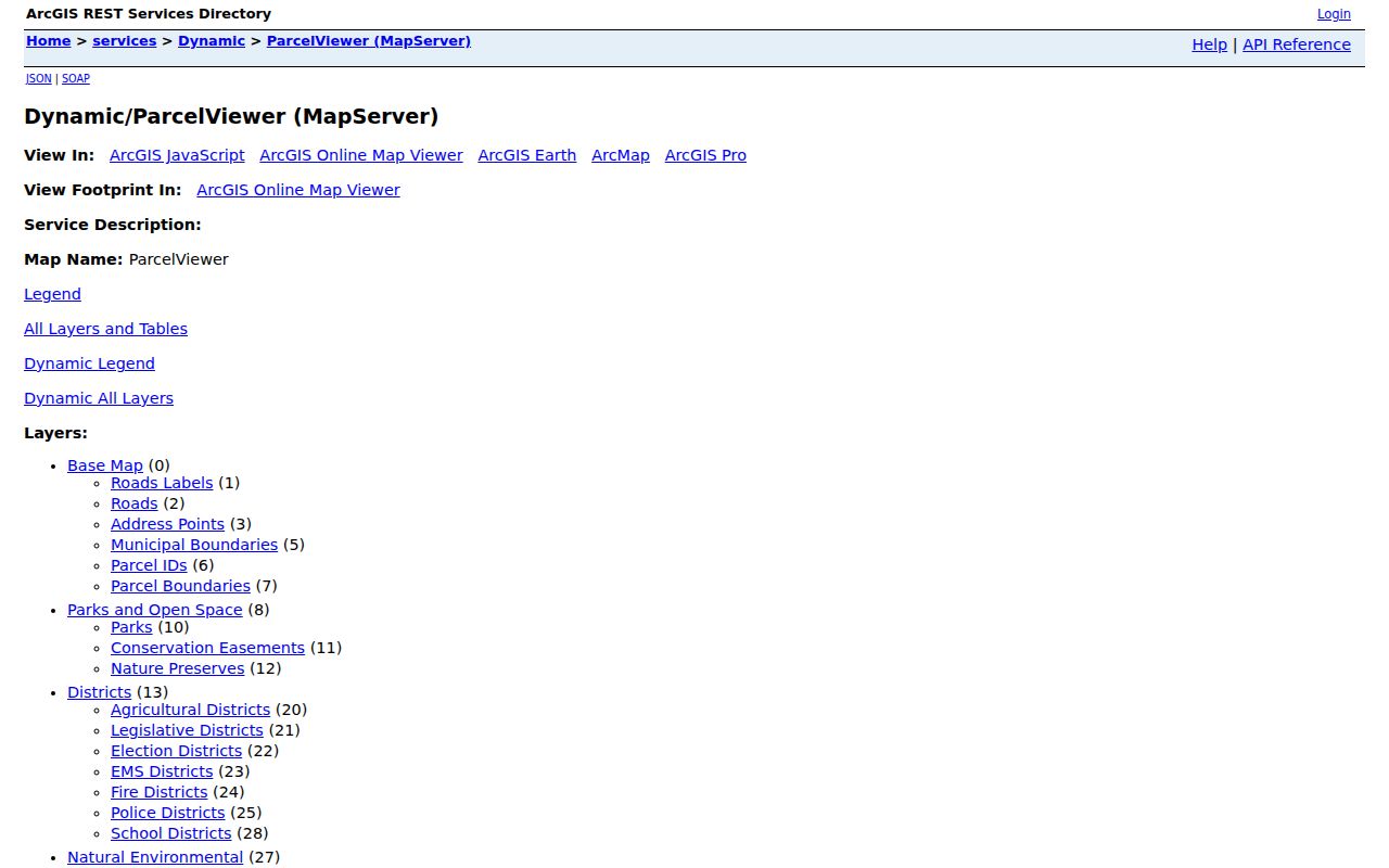
The service lists parcel boundaries, parcel IDs, road labels, address points, and municipal boundaries. It also includes district groups for elections, schools, fire, police, EMS, agriculture, and legislative areas. Follow the parcel from the map to its tax record, then compare the property location with any owner mailing address as the record displays them.
- Parcel
- A mapped tax-property unit. It is the stable geographic starting point for nearby-record research.
- Property location
- The physical situs address of the parcel, which can differ from an owner's mailing address.
- Legal description
- The deed or plat description that ties land records to the correct parcel when an address alone is unclear.
Town of Wallkill Neighbor Geography
One block may cross more than a simple street label. Orange County's parcel layers show municipal boundaries and multiple district overlays, including election, school, fire, police, EMS, agricultural, and legislative districts. The election-district map is useful for putting a Town of Wallkill address in civic geography before asking whether an election record is available for a particular period.
Town geography has a local wrinkle. The Town of Wallkill nearly surrounds the independent City of Middletown, and a Middletown postal label does not by itself settle the municipality of a property. Circleville, Howells, Scotchtown, Mechanicstown, and New Hampton can also appear as hamlet, station, or postal-locality labels in older material. Confirm the municipality and parcel, rather than relying on the postal city printed in an address.
Town of Wallkill Neighbor Voter Limits
New York Election Law §5-602 permits county boards, before the fifth day before a general election, to publish complete registered-voter lists by election district. The list may be arranged by street and number or alphabetically, can mark inactive status, and is available for public examination in the statutory setting. It is a dated election record, not a continuously updated block directory. The New York State voter registration lookup is for verifying a registrant's own record, not for anonymous street searching.
Election Law §5-508 protects confidential registration. Qualifying voters provide a sworn statement to the county board, and the separate record is unavailable for public inspection or copying except as needed by an election official. A voter list also does not reveal ballot choices. When a lawful civic or historical question needs a voter source, start with the address-to-district connection, then use the applicable Board of Elections procedure and its purpose limits.
Town of Wallkill Neighbor Directory Result
No authoritative inventory of Town of Wallkill neighborhood associations, homeowners associations, block-watch rosters, or member directories was located. That is a result worth keeping in view. A subdivision may have documents or a community group may publish its own contact, but neither fact supports a claim that there is one townwide directory of neighbors.
When the address or subdivision is known, check Town public-document and planning materials for the specific property context. For older community connections, the record trail is stronger at Thrall Library, historical collections, and the Orange County Genealogical Society. Those sources may preserve church directories, photographs, city directories, or family folders. They are historical research aids, not current-contact lists.
Town of Wallkill Neighbor Records Compared
Official parcel records have a defined custodian, a property-specific scope, and a route for confirming the source. Unnamed commercial neighbor tools can combine data from many sources, but they may not reveal how a name was matched to an address or when a record changed. Start with the official record that answers the property question, then treat any outside result as unverified until the custodian supports it.
| Official parcel and land records | Commercial neighbor tools |
|---|---|
| Identify a parcel, recorded owner, assessment context, or recorded instrument through Orange County systems. | May combine data from sources with unclear timing, matching, or correction paths. |
| Connect a fact to a map, property system, or County Clerk custodian. | Can suggest a lead, but does not replace parcel-by-parcel verification. |
| Carry explicit limits: owner is not every resident, and GIS is not a legal survey. | May blur owners, prior addresses, and household members into a result that needs independent checking. |
There is also a local access contrast within the Clerk's systems. Free Historic-Only SearchIQS access does not include land records, while paid land index and image access has daily and 90-day tiers. The County Clerk's Record Room remains the direct alternative when online access is incomplete or a document needs a closer look. Visitors can use free public computers there to inspect deeds, mortgages, maps, liens, judgments, and court actions. Ask which record series and copy method fit the narrow property question.
Protect Town of Wallkill Neighbors
Some information around a block is not a public lookup. Utility and delivery records are not public sources for a block inquiry, and federal law restricts disclosure of personal information from motor-vehicle records. A property owner is not necessarily the occupant. New York's Address Confidentiality Program can require a substitute mailing address in qualifying government records, while confidential voter registration has its own protection.
For an assessment, recorded-document, or court-record error, ask the custodian about its correction or redaction process. The New York Address Confidentiality Program is a separate safety path for eligible participants. It does not automatically erase historical records or compel every private company to accept a substitute address.
Lawful personal research. Use Town of Wallkill neighbor records for a limited, legitimate property, historical, or civic question. Do not use them to stalk, harass, threaten, expose a protected address, or harm another person.